Trail Walking Gorenja vas-Poljane - Jagorje - Photo
 avdem
avdem

User

© OpenStreetMap contributors
Length
Length
3.1 km
Max alt
Max alt
932 m
Uphill gradient
Uphill gradient
230 m
Km-Effort
Km-Effort  
5.6 km
Min alt
Min alt
699 m
Downhill gradient
Downhill gradient
61 m
Boucle
Boucle
No
Creation date :
2019-08-26 11:42:10.625
Updated on :
2019-08-26 13:00:58.164

(0 Reviews)

Walking
Walking
1h19
Difficulty : Medium

Scan this QR Code to open this trail in the SityTrail application

FREE GPS app for hiking

Logo SityTrail SityTrail

IGN / Geographical institutes

Download SityTrail from the App Store Download SityTrail from Google Play

Logo SityTrail SityTrail World

The world is yours!

Download SityTrail from the App Store Download SityTrail from Google Play Download SityTrail on Huawei AppGallery

About

Trail Walking of 3.1 km to be discovered at Unknown, Unknown, Gorenja vas-Poljane. This trail is proposed by avdem.

Description

Apres le goulash retour a Zapreval

Elevation profile

Positioning

Country:
Slovenia
Region :
Unknown
Department/Province :
Unknown
Municipality :
Gorenja vas-Poljane
Location:
Unknown
Start:(UTM)
436545 ; 5111952 (33T) N.

Trails nearby

Trail Walking Gorenja vas-Poljane - zapreval a Jagorje - Photo
Walking
avdem

Walking

Medium
Gorenja vas-Poljane, Unknown, Unknown, Slovenia
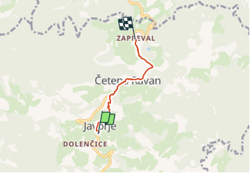
6.8 km | 10.3 km-effort
2h 44min
No


Close
My subscriptions